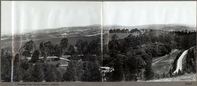
Sather Park - 1917 Sather Park Tract is now known as Lakeshore Highlands and Trestle Glen. I have shared a few of the photos from an album entitled "Lakeshore Highlands" that was prepared for Frederick Law Olmsted who was hired by Walter H. Leimert. The album is from the archives of Olmsted at the Frederick... Continue Reading →
Alden Farm
Official and historical atlas map of Alameda County, California. Compiled, drawn, and published from personal examinations and surveys by Thompson & West. Oakland, Cala. 1878. Res. & farm of P.A. Finigan, Brooklyn Tp. The Alden Farm (Alder Farm) once stood on the land where Holy Names University is located today. In 1874 Charles Low owned... Continue Reading →
Sunalta or Montclair?
The Sunalta District - was almost the name given to Montclair. In 1919, the Oakland Real Estate Board advertised in Oakland Tribune a "$50 cash Prize" to come up with a name for the area now called Montclair. Oakland Tribune Nov 6, 1919 The deadline was Jan 1, 1920. On Jan 11, 1920, the Tribune... Continue Reading →
Edenvale – The Talbot Estate
In 1888, Frederick C. Talbot of the San Francisco lumber firm of Pope & Talbot purchased 133- acres from Ellis A. Haines in Elmhurst near San Leandro and adjacent to the Souhter Farm ( now the Dunsmuir Home) for $15,000. This is now the home of Knowland Park and the Oakland Zoo.
Old Mountain George
Again while researching something else, I came across this, and I had to share it. I was looking into the Haines Ranch and found this article about Mountain George. Old Mountain George Died Where He Wanted to Die On the 15th day of July 1887, Jonathan Murphy was riding over the ridge close to (or... Continue Reading →
Freeway Variety
Freeway Variety Photo by Bill Boyd C 1978 If you grew up the Montclair District of Oakland from 1956 to about 1990, you shopped at Freeway Variety. The Montclarion March 1956 Freeway Variety opened in March of 1956. It was owned and operated by partners Cy Fritz and David Iventosch. They both had experience running... Continue Reading →
Lynde Street – Geo L. Lynde
I've always been curious about the meaning behind a street name. Some are obvious like Broadway or Main Street. I've lived on Capricorn Ave (zodiac), Thornhill Dr. (Hiram Thorn) Georgia St. (the state) Athol Ave (still haven't figured that one out), and Lynde St.Lynde Street was declared a public road in 1886.
Oakland and Surroundings – Then and Now
A few of the illustrations from the 1885 Oakland and Surrounding compared to modern-day or an earlier date. Nichol Block The Nichol Block was built in 1878 and is now a part of "Old Oakland." It is located at the northeast corner of 9th Street and Washington. Northeast corner of 9th and Washington Streets. Arlington... Continue Reading →
William Keith – Artist
I found the following article when I was doing the research for my post on the Hays Canyon Murder and another I am working on. I immediately went searching for the paintings, and I found photos of them. Absolutely beautiful. Sharing what I found. The first painting is somewhere in the hills above Piedmont. Oakland... Continue Reading →
Ardsley Heights
Ardsley Heights is part of Bella Vista Park and is now considered part of Ivy Hill. The streets of Ardsley Heights are Park Blvd, East 28th Street, Bay View Avenue, Lake View Avenue Elliot Street, and East 34th Street. Ardsley Heights Tract Map Blocks G&H of Bella Vista Park 1912 From Earth Sciences and Map... Continue Reading →


